Japan is one of the most volcanically active countries on earth, sitting at the junction of four tectonic plates. Kyushu alone has five significant volcanic systems: Aso, Sakurajima, Unzen, Kirishima, and the Beppu geothermal field. All are active. All are reachable by road. Most can be visited in a single two-week campervan loop.
For Japanese domestic tourists, volcanoes are part of the background — a fact of geography, present but not defining. For travelers from the flat limestone plains of Western Europe, the deserts of the Middle East, or the non-volcanic East Coast of North America, the idea of driving to an active volcano crater before lunch is not a normal experience. It is, for many, a once-in-a-lifetime one.
This is why international travelers' Kyushu itineraries so frequently center on volcanic destinations that Japanese guidebooks treat as one feature among many.
Kyushu's Volcanic Arc: What You're Working With
Understanding Kyushu's geology helps you plan a better itinerary. The island sits above the subduction zone where the Philippine Sea Plate dives beneath the Eurasian Plate. This process generates magma that feeds all of Kyushu's volcanic activity. The volcanoes are not random — they form a rough arc running from Beppu in the northeast to Sakurajima in the south.
That arc is short enough to drive in a day if you push it — but worthy of several. Here are the five systems, what they offer, and why they matter.
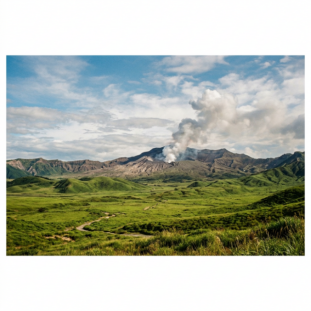
1. Mount Aso (阿蘇山) — The Caldera That Contains Towns
Aso is the largest volcanic caldera in the world by some measures — 25km east to west, 18km north to south, with approximately 50,000 people living inside it. Towns, farms, hot springs, and the active Nakadake crater all share the same caldera floor. You can drive into the caldera and feel, gradually, that the walls around you are impossibly high — because they are the rim of a volcano that last erupted catastrophically 90,000 years ago.
The active Nakadake crater is the smoking heart of the system. When the alert level is at Level 1, you can drive to within 100 meters of the crater rim and look down into the sulfurous pool below. The smell arrives before you see anything. The sound — wind and distant rumble — precedes the view. It's one of the most viscerally geological experiences accessible to ordinary travelers anywhere on earth.
Beyond the crater: Kusasenri meadow (a flat grassland at 1,100m with a shallow pond where horses graze), Daikanbo viewpoint (a panoramic view of the entire caldera from the north rim), and the surrounding Yamanami Highway — one of the great scenic drives in Japan.
⚠️ Aso Volcanic Alert
Check the Japan Meteorological Agency alert level before planning crater access. Level 1: open. Level 2: crater area restricted. Level 3+: no public access. The caldera, Kusasenri, and Daikanbo are accessible regardless of alert level.
2. Sakurajima (桜島) — The Active Island You Can Drive Onto
Sakurajima is a stratovolcano that erupts hundreds of times per year — small eruptions, usually, but visible columns of ash and smoke rising from the summit on most days. It sits in Kagoshima Bay, connected to the Osumi Peninsula by a lava flow from a 1914 eruption that was so large it bridged the 400-meter channel between the island and the mainland.
You drive onto Sakurajima via that same lava bridge, then loop the island on a single road. There are multiple viewpoints, lava field walks, an onsen where you dig your own footbath in the volcanic sand, and a visitor center explaining the island's eruptive history. Kagoshima City — visible across the bay — gets volcanic ash on its streets regularly. Residents keep umbrellas for ash as naturally as for rain.
For most international visitors, Sakurajima is the first time they've been physically adjacent to a continuously erupting volcano. The eruptions are small enough to be safe at road distance but large enough to see clearly: a sudden darkening above the summit, then a column of ash rising thousands of meters. If conditions are right, you'll see this happen while you're there.
3. Unzen (雲仙) — The Volcano That Shaped History
Unzen's most recent major eruption was in 1991 — devastating pyroclastic flows that killed 43 people including volcanologists and journalists who got too close. The disaster is well-documented and deeply felt in the region. The Unzen Disaster Memorial Museum in Shimabara tells the story in detail.
What visitors encounter today is the active hell ponds of Unzen Jigoku — a cluster of boiling sulfurous pools, some clear and blue, others milky white, others an opaque grey, all steaming visibly at any temperature. The smell is intense. The sound of boiling earth is constant. You walk through it on a wooden boardwalk, close enough to feel the heat. Hot spring eggs cooked in the boiling water are sold at the entrance.
Above the hell ponds, Unzen Nita Pass provides access to the summit area and views across the Shimabara Peninsula to the bay. The drive up is worth it for the changing vegetation alone — subtropical coast to alpine shrub in 30 minutes.
4. Kirishima (霧島) — The Range Where Japan Began
Kirishima is a volcanic range rather than a single peak — 23 volcanoes, some active, spread across the border of Kagoshima and Miyazaki Prefectures. The highest, Mt. Karakunidake (1,700m), can be hiked in a few hours from the trailhead and on clear days offers views to Sakurajima, Aso, and the Pacific coast.
The range contains Rokukan'non Miike — a crater lake with vivid green water — and several hiking trails connecting peaks and crater rims. The Kirishima onsen towns below the range, including the oldest rock bath in the area (Me no Yu), make for natural base camps. Japanese mythology places the divine descent to earth at Takachiho-no-mine, one of the Kirishima peaks — a story that gives the landscape additional weight for those who know it.
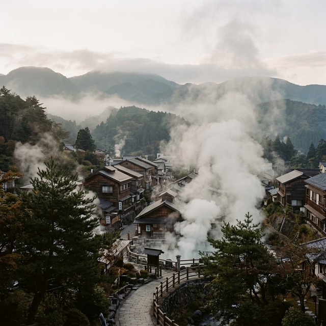
5. Beppu (別府) — Geothermal Theater
Beppu is not a volcano you can see — it's a city sitting above one of the most concentrated geothermal fields on earth. Over 2,000 hot spring sources, more than any other place in Japan. The Beppu Hell Tour (地獄めぐり) visits seven distinct geothermal pools: one is cobalt blue (Umi Jigoku, "Sea Hell"), one is blood red (Chi no Ike Jigoku, "Blood Pond Hell"), one is grey-green, one has alligators living in its heated water, one is a mud pool that burbles constantly like a thick porridge.
Beppu's hells are explicitly theatrical — the naming and presentation are designed for visitors. But the underlying geology is entirely real. The temperature, color, and behavior of each pool is determined by the specific mineral content of the water and the depth at which it contacts the magma system below. Standing at the rim of Umi Jigoku, the water is 98°C and genuinely a saturated blue that looks painted.
Planning a Volcanic Kyushu Van Route
A logical order from Fukuoka follows the arc southwest:
- Beppu (northeast Kyushu) — hell tour, one night
- Yufuin (nearby) — gentle contrast, specialty cafés, one night
- Mount Aso (central Kyushu) — two nights minimum, crater + caldera exploration
- Kirishima (south-central) — hiking, crater lakes, onsen, one or two nights
- Sakurajima (south) — loop the island, one night in Kagoshima area
- Unzen (via Shimabara Peninsula) — hell ponds, disaster memorial, one night
- Return to Fukuoka via western coast
Total: 7–10 days. Total distance: approximately 1,000–1,200km. Manageable in a campervan with no rushing.
Frequently Asked Questions
Which volcanoes in Kyushu can you visit?
All five of Kyushu's major volcanic systems are accessible to travelers: Mount Aso (active crater, world's largest caldera), Sakurajima (continuously active, driveable island), Unzen (active hell ponds, post-eruption landscape), Kirishima (volcanic range, multiple peaks and crater lakes), and Beppu (geothermal field with seven spectacular hell pools). All can be combined in a single campervan loop from Fukuoka.
Is it safe to visit active volcanoes in Japan?
Japan's volcanoes are among the most closely monitored in the world. The Japan Meteorological Agency publishes real-time alert levels. Level 1 means normal activity with crater access generally open. Level 2 restricts crater proximity. Level 3+ closes public access entirely. Caldera communities, viewpoints, and surrounding areas remain safe to visit at all alert levels. Always check the JMA website before planning crater visits.
What is the best order to visit Kyushu's volcanoes by campervan?
From Fukuoka: Beppu → Aso (2 nights) → Kirishima → Sakurajima → Unzen → return. This follows the volcanic arc southwest and allows each system enough time. Total 7–10 days, roughly 1,000–1,200km.